Resolving Land Conflict through Participative Mapping

Supported by his expertise in reading scale and point coordinator, Iskandar (33) started mapping the village borders in a sub-district in the Sambas district in West Kalimantan province.
“In the past, I have almost no knowledge at all about mapping, moreover about GPS,” noted Iskandar.
The mapping result could now be used as valid reference to the local community, government, or companies who want to establish their operations at the area.
Through the years, however, Iskandar has nurtured his skills in mapping. And the skills have been a valuable treasure to help resolve land conflicts at the village level in Sambas area, such as in the Teluk Keramat sub-district. Unclear village borders have often ignited heated communal tensions among the villagers in several areas near the West Kalimantan-Sarawak (Malaysia) border in the last decade. The tension also occurred with the companies setting up oil palm estates in the area, which oftentimes claimed some parts of village land as their areas to plant oil palm.
In some cases, the villagers could not claim and protect their land because they did not know the exact borders of their villages. In Teluk Keramat sub-district, for example, all its 24 villages still have no clear borderlines against each other. The villagers also had almost no access to the official map, which sometimes resulted in heated polemics among the community groups.
The participative mapping initiative introduced by Wahana Visi Indonesia Office in Sambas (Wahana Visi Indonesia is a partner of World Vision) tried to resolve such a tension. As the program name implied, the mapping is done under the participation of relevant parties, such as the local community, the local government, the agency for community empowerment, and the community leaders in neighboring villages, and other relevant representatives.
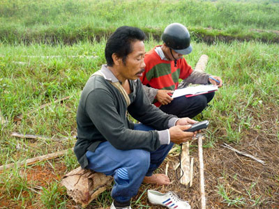
The process of participative mapping in Lela village, Teluk Keramat sub district
Such a joint mapping process could open dialogs, negotiations, and decisions to map out much clearer border lines.
Through such an approach, the mapping process at the Lela village in Teluk Keramat could be satisfactorily completed. The mapping result could now be used as valid reference to the local community, the government, or the companies who want to establish their operations at the area. The mapping committee has also generously shared the skills in the mapping process to scores of local cadres from other villages so that the future mapping process could be accelerated.
The participative mapping is one of the five programs of the Strengthening Livelihoods and Reducing Local Vulnerabilities (SOLVE) special program introduced in Sambas by Wahana Visi, a special partner of World Vision. This program, started in 2011, would end later this year. The other four programs under the SOLVE initiative are mobile library to reach schools in remote places, identifying and supporting villages in Sambas with the highest diarrhea prevalences, the green and harmony schooling program in three places, and the economic empowerment in the supported villages.
The project also supports vulnerable community groups living at some villages close to the Indonesia-Malaysia border. Some community groups there still could not enjoy better life quality due to many factors, including unclear land areas, and the interventions of scores of agencies.
Wahana Visi programs in Sambas reaches almost 14,000 people of Dayak and Melayu tribes in the Sanjingan and Teluk Keramat sub-districts. Among the supported villages are Sebunga, Kaliau, Sanatab, Sui Bening, Santaban, Lela, Trimandayan, Sayang Sedayu, and Tambatan.(Editor and Translated by Hendro Suwito, Senior Editor World Vision Indonesia)